Trip Explanation: Everest Base Camp Trek
Your journey through the lively Kathmandu streets will lead you to the heart of Himalayan mountains during your Everest Base Camp Trek. The adventure starts with an awe-inspiring 35-minute flight from Kathmandu to Lukla during which passengers will enjoy breathtaking views of the hills and mountains and valleys and snowy peaks stretching across the landscape. The excitement from walking through the Tenzing-Hillary Airport's thrilling airstrip increases as one witnesses this world-class landing facility before starting the trail.
From Lukla, the trek officially begins as we make our way to Phakding, a charming village nestled along the Dudh Koshi River. The peaceful riverside setting makes for a perfect first overnight stop, preparing us for the journey ahead. The next day, we ascend to Namche Bazaar, the bustling hub of the Khumbu region. Once a vital trade post between Nepal and Tibet, Namche is now a vibrant town filled with cozy lodges, bakeries, cafes, museums, and monasteries. It’s also our first acclimatization stop, where we take an extra day to explore and hike to Everest View Hotel, one of the highest-altitude hotels in the world, offering a spectacular panoramic view of Everest and its surrounding peaks.
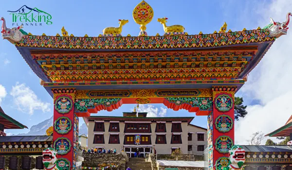
As we continue, the trail leads to Tengboche, home to the Tengboche Monastery, the most significant spiritual site in the region. Here, we experience the deep-rooted Buddhist culture, receive blessings from monks, and take in breathtaking views of Ama Dablam and Everest. The journey then takes us to Dingboche, where we spend another acclimatization day, hiking to Nangkar Tshang Peak for even more mesmerizing mountain vistas.
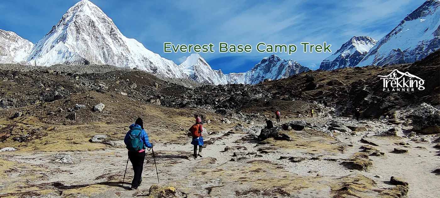
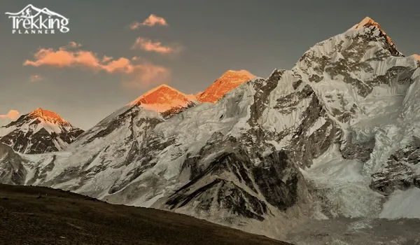
Leaving Dingboche, we push forward to Lobuche, where the landscape turns more rugged and dramatic, with towering peaks surrounding us at every turn. From Lobuche, we trek to Gorakshep, the final settlement before reaching our ultimate destination—Everest Base Camp. Standing at the base of the world’s highest mountain, surrounded by iconic yellow expedition tents and the Khumbu Glacier, is an indescribable feeling. While the full summit of Everest isn’t visible from base camp, we get an unobstructed view the next morning from Kala Patthar, the highest point of the trek at 5,545 meters. Watching the sunrise over Everest from Kala Patthar is a moment that stays with you forever.
After soaking in the views, we begin our descent, retracing our steps through Pheriche, Namche, and Lukla. The return journey offers a chance to take in the landscapes from a fresh perspective and reflect on the incredible experience. Finally, we take an early morning flight back to Kathmandu, where we celebrate the completion of this life-changing trek with a well-earned meal and the joy of knowing we stood at the foot of the world’s tallest mountain.
Everest Base Camp Trek Map: 12 Days
Trekking to Everest Base Camp for 12 days is more than just a journey—it’s an experience of a lifetime. Standing at the foot of the world’s highest mountain is a dream for many, and this 12-day trek offers the perfect balance of adventure, culture, and breathtaking scenery.
A good Everest Base Camp Trekking Map is essential for navigating the route, tracking elevation gains, and identifying key landmarks. It highlights glacial rivers, suspension bridges, and cultural sites, helping you plan your journey and fully appreciate every step.
This trek isn’t just about reaching Everest Base Camp—it’s about the adventure, the people you meet, and the memories you create along the way.

Outline Itinerary: Everest Base Camp 12 Days Trek
- Day 1: Take a morning flight from Kathmandu to Lukla (2,860m/9,383ft), 35 min, and trek to Phakding (2,610m/8,560ft) 4-hour trek., a walking distance of 8 km/5 miles, and Total Elevation Gain of 230 m/ 755 ft.
- Day 2: Trek to Namche Bazaar (3,440m/11,286ft) 5-6 hrs walk, Walking Distance: 10.5 km / 6.5 miles and Total Elevation Gain 830 m/ 2723 ft
- Day 3: Rest day at Namche Bazaar for acclimatization and local excursion; Hike to Everest View Hotel 3880 m/12730 ft and Total Elevation Gain 440 m/ 1444 ft
- Day 4: Trek to Tengboche (3,860m/12,664ft) 4-5 hrs walk, Walking Distance: 9 km / 5.6 miles and Total Elevation Gain 420 m/ 1378 ft.
- Day 5: Trek to Dingboche (4,410m/14,469ft) 4-5 hrs walk, Walking Distance: 12 km / 7.45 miles and Total Elevation Gain 550 m/ 1805 ft.
- Day 6: Rest day at Dingboche for acclimatization and excursion, Hike to Nangkartshang Peak 5083 m/16677 ft and Total Elevation Gain 673 m/ 2208 ft
- Day 7: Trek to Lobuche (4,940m/16,210ft) 4-5 hrs walk, Walking Distance: 8 km / 5 miles and Total Elevation Gain 500 m/ 1640 ft.
- Day 8: Trek to Gorakshep (5,164m/16,942ft) 3-4 hrs walk and Everest Base Camp (5,364m/17,598ft) 2-3 hrs walk, Walking Distance: 15 km / 9.32 miles and Total Elevation Gain 475 m/ 1489 ft.
- Day 9: Hike to Kalapathar (5,545 m/ 18,193 ft) and continue trekking to Pheriche (4,371 m /14,340 ft) 6-7 hour trek, walking Distance: 12 km /7.45 miles and Total Elevation Gain 415 m + 810 m/ 1362 ft + 2655ft
- Day 10: Trek from Pheriche to Namche Bazaar (3,440 m/11,286 ft) 6-7 hour trek, walking Distance: 14 km /8.7 miles and Total Elevation Gain 800 m/2625 ft
- Day 11: Trek from Namche Bazaar to Lukla (2,860m/9,383ft) 6-7 hour trek, walking Distance: 19 km /11.8 miles and Total Elevation Gain 612 m/2008 ft
- Day 12: Fly back to Kathmandu (1,350m/4,430ft )
Everest Base Camp Trek Map - 13 Days
A detailed Everest Base Camp 13-Day Trek Map helps trekkers navigate the route, track elevation changes, and identify key landmarks such as Tengboche Monastery, Kala Patthar, and Everest Base Camp. The map also provides insights into daily trekking distances, helping hikers pace themselves for the journey ahead.
This trek is more than just reaching Everest Base Camp—it’s about embracing the adventure, connecting with the Sherpa culture, and experiencing the awe-inspiring beauty of the Himalayas.
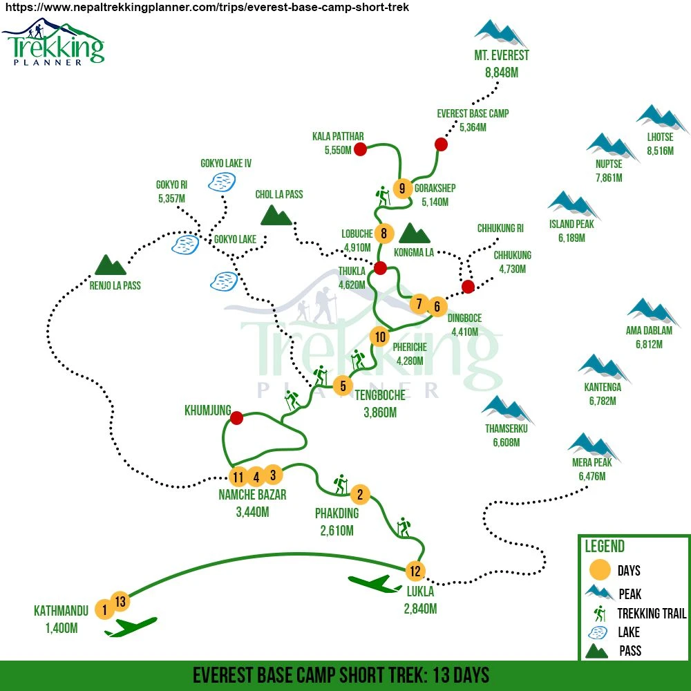
Short Itinerary: Everest Base Camp 13 Days Trek
- Day 1: Arrival in Kathmandu (1,350m/4,430ft)/Group meeting
- Day 2: Flight to Lukla (2,860m/9,383ft) 35m and trek to Phakding (2,610m/8,560ft) 3-4 hrs walk, Walking Distance: 8 km / 5 miles and Total Elevation Gain 230 m/ 755 ft
- Day 3: Trek to Namche Bazaar (3,440m/11,286ft) 5-6 hrs walk, Walking Distance: 10.5 km / 6.5 miles and Total Elevation Gain 830 m/ 2723 ft
- Day 4: Rest day at Namche Bazaar for acclimatization and local excursion; Hike to Everest View Hotel 3880 m/12730 ft and Total Elevation Gain 440 m/ 1444 ft
- Day 5: Trek to Tengboche (3,850m/12,632ft) 4-5 hrs walk, Walking Distance: 9 km / 5.6 miles and Total Elevation Gain 420 m/ 1378 ft
- Day 6: Trek to Dingboche (4,410m/14,468ft) 4-5 hrs walk, Walking Distance: 12 km / 7.45 miles and Total Elevation Gain 550 m/ 1805 ft
- Day 7: Rest day at Dingboche for acclimatization and excursion, Hike to Nangkartshang Peak 5083 m/16677 ft and Total Elevation Gain 673 m/ 2208 ft
- Day 8: Trek to Lobuche (4,910m/16,109ft) 4-5 hrs walk, Walking Distance: 9 km / 5.6 miles and Total Elevation Gain 500 m/ 1640 ft
- Day 9: Trek to Gorakshep (5,164m/16,942ft) 3-4 hrs walk and Everest Base Camp (5,364m/17,598ft) 2-3 hrs walk, Walking Distance: 15 km / 9.32 miles and Total Elevation Gain 475 m/ 1489 ft
- Day 10: Trek to Kala Patthar (5,545m/18,193ft) 2-3 hrs walk and to Pheriche (4,280m/14,042ft) 5-6 hrs walk, Walking Distance: 13 km /8.07 miles and Total Elevation Gain 415 m + 810 m/ 1362 ft + 2655ft
- Day 11: Trek to Namche bazaar (3,440m/11,286ft) 4-5 hrs walk, Walking Distance: 14 km /8.7 miles and Total Elevation Gain 800 m/2625 ft
- Day 12: Trek to Lukla (2,860m/9,383ft) 5-6 hrs walk, Walking Distance: 19 km /11.8 miles and Total Elevation Gain 612 m/2008 ft
- Day 13: Fly back to Kath
Everest Base Camp Trek Map - 14 Days
The Everest Base Camp Trek is an adventure of a lifetime, taking you to the base of the world’s tallest mountain. Many trekkers visit Nepal with a dream of standing at the foot of Mount Everest, experiencing both the thrill of the journey and the breathtaking beauty of the Khumbu region.
A detailed Everest Base Camp 14-Day Trek Map is an essential guide, showing key villages, altitude changes, and significant landmarks along the way. A map enables trekkers to control elevation increases and schedule rest periods and locate prominent landmarks and glaciers with monasteries. As an essential navigation tool the map enables users to maintain progress tracking and ensure they experience every notable feature on their way.
The Everest Base Camp Trek weaves together thrilling adventures alongside ethnic encounters with extraordinary natural views which creates an everlasting change in life experience.
Outline Itinerary: Everest Base Camp Trek- 14 Days Map
- Day 1: Arrival in Kathmandu and trip preparation (1,350m/4,429ft) about 20-25 min drive from the airport
- Day 2: Take a morning flight from Kathmandu to Lukla (2,860m/9,383ft) for 35 minutes and trek to Phakding (2,610m/8,560ft). It is a 4-hour trek, 7.5 km/4.6 miles long, and Total Elevation Gain of 230 m/ 755 ft.
- Day 3: Trek to Namche Bazaar (3,440m/11,287ft) 5-6 hrs walk, Walking Distance: 12 km / 7.45 miles and Total Elevation Gain 830 m/ 2723 ft.
- Day 4: Rest day at Namche Bazaar for acclimatization and local excursion; Hike to Everest View Hotel 3880 m/12730 ft and Total Elevation Gain 440 m/ 1444 ft
- Day 5: Trek to Tengboche (3,850m/12,632ft) 4-5 hrs walk, Walking Distance: 10 km / 6.21 miles and Total Elevation Gain 420 m/ 1378 ft.
- Day 6: Trek to Dingboche (4,350m/14,272ft) 4-5 hrs walk, Walking Distance: 12 km / 7.45 miles and Total Elevation Gain 550 m/ 1805 ft.
- Day 7: Rest day at Dingboche for acclimatization and excursion, Hike to Nangkartshang Peak 5083 m/16677 ft and Total Elevation Gain 673 m/ 2208 ft
- Day 8: Trek to Lobuche (4,910m/16,109ft) 4-5 hrs walk, Walking Distance: 12 km / 7.45 miles and Total Elevation Gain 500 m/ 1640 ft.
- Day 9: Trek to Gorakshep (5,180m/16,995ft) 3-4 hrs walk and Everest Base Camp (5,364m/17,598ft) 2-3 hrs walk, Walking Distance: 15 km / 9.32 miles and Total Elevation Gain 475 m/ 1489 ft.
- Day 10: Hike to Kalapathar (5,545 m/ 18,192 ft.) and continue trekking to Pheriche (4,371 m /14,340 ft) 5-hour trek, walking Distance: 13 km /8.07 miles and Total Elevation Gain 415 m + 810 m/ 1362 ft + 2655ft
- Day 11: Trek from Pheriche to Namche Bazaar (3,440 m/11,286 ft) 6-hour trek, walking Distance: 14 km /8.69 miles and Total Elevation Gain 800 m/2625 ft
- Day 12: Trek from Namche Bazaar to Lukla (2,828m/9,279ft.) 6-hour trek, walking Distance: 21 km /13.0488 miles and Total Elevation Gain 612 m/2008 ft
- Day 13: Morning flight from Lukla to Kathmandu
- Day 14: Transfer to the airport and fly back home
Everest Base Camp Trek Google Map
When I was planning my Everest Base Camp trek, using Google Maps gave me a great sense of the route and what to expect. It helped me visualize key stops like Lukla, Namche Bazaar, Tengboche, Dingboche, and Gorakshep, leading up to Everest Base Camp at 5,364m. Seeing the altitude changes, trekking distances, and major landmarks like Tengboche Monastery, Kala Patthar, and the Khumbu Glacier on the map made the trek feel even more real before I set foot on the trail.
While Google Maps is fantastic for planning, I quickly realized that once I was deep in the Himalayas, internet access was unreliable. That’s why having a physical map and GPS device was just as important. Still, whether you’re prepping for the trek or just daydreaming about the adventure, exploring the Everest Base Camp trek on Google Maps is a great way to get inspired!
Contact Us
So, join Trekking Planner Nepal Pvt Ltd for an exciting 12-day Everest Base Camp trek. We are a reputable company organizing tours, trekking, and helicopter flights for over a decade. So, allow us to explore the Everest region and be a part of Nepal's trekking story.
Contact us through email, WhatsApp, or any other social media platform. We are available on Facebook, Instagram, and Viber, so feel free to ask us any questions. Likewise, individuals can ask us about any trekking preparation tips or queries.