
Introduction
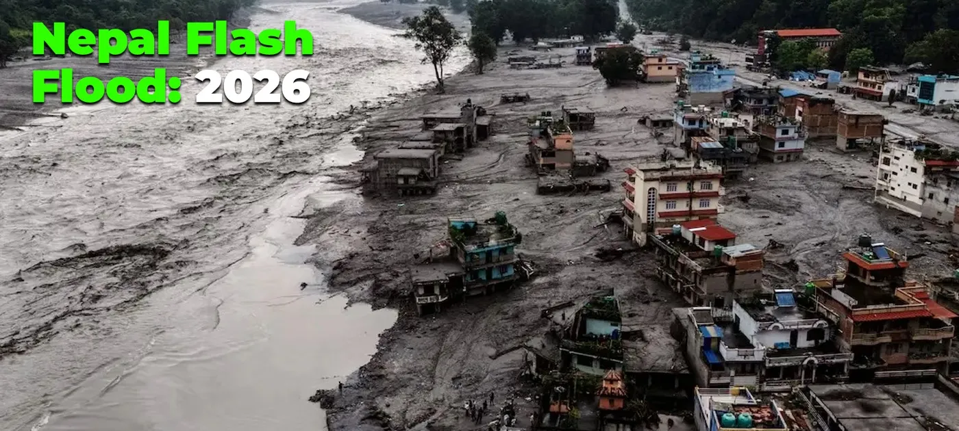
A major natural disaster has struck Nepal once again. On the morning of August 26, 2026, a sudden and catastrophic flash flood surged through the Lhende Khola river valley in Rasuwa district in Northern Nepal. The floodwater, along with the mixture of mud and debris, rushed down the Bhotekoshi corridor causing severe destruction in the major settlements close to Rasuwagadhi, Timmure and Syabrubesi. Further continuing down the Trishuli river system, the flood caused extensive human and infrastructural damage across Nuwakot,Dhading and other districts as well.
Images and videos of washed-out roads, collapsed bridges and other infrastructures, and affected communities, blowing up across social media platforms have understandably raised concerns among travellers who are planning to visit Nepal in the near future. The scale of the disaster and the visuals circulating across social media can definitely create an impression that Nepal is unsafe or that tourism has come to a halt.
Nepal, however, is a geographically diverse country. The conditions in one river valley or one river system does not automatically affect the conditions in other trekking or traveling routes across the country. The safety conditions must always be assessed region by region and specific routes, local infrastructures and official advisories must be taken into account before coming up to a conclusion.
This blog aims to provide a clear overview and the latest updates regarding what happened in Rasuwa, the occurrence of flood, human and infrastructural loss, affected areas, impact on tourism, the current status of major trekking regions, safety advice for travellers, and links to official sources so you can make informed decisions for your Nepal trip.
What Exactly Happened in Rasuwa?
Rasuwa is a mountainous district situated in Bagmati Province in Northern Nepal. It shares a border and a prominent trading and immigration route with China (Tibet). Rasuwa is renowned among travelers, trekkers and pilgrims as an important gateway to the Langtang valley and the sacred Gosaikunda lake. The district’s major settlements along the Bhote Koshi river corridor include Syabrubesi, Timure and the Rasuwagadhi border crossing. The Bhote Koshi River flows through these narrow valleys before joining the Trishuli river further into the south.
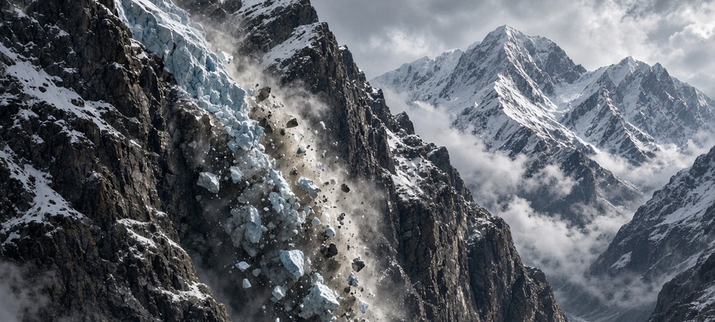
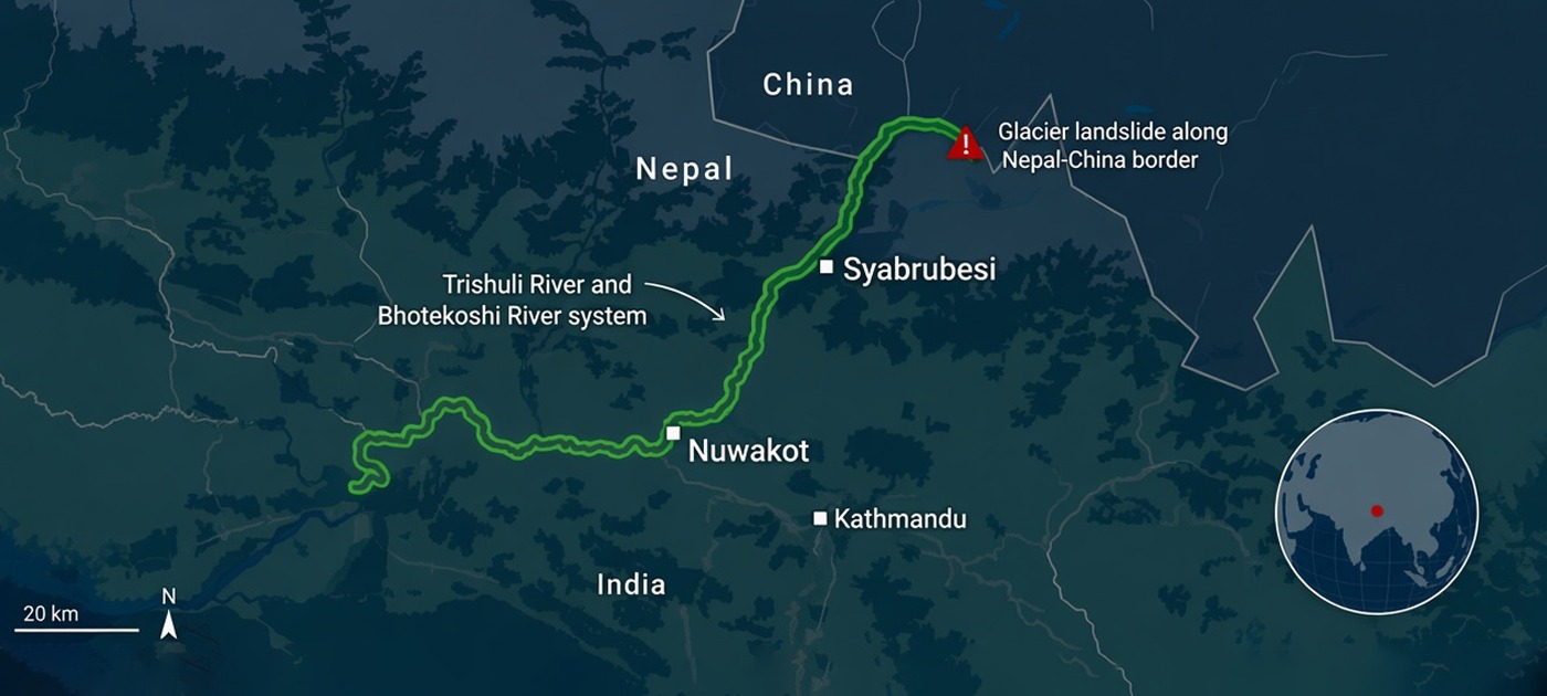
On the morning of 26 Aug 2026, a large chunk of a glacier collapsed in the Himalayas along the Nepal-Tibet border. The debris crashed down and temporarily blocked the Lhende Khola, creating a natural dam. When the natural dam failed, the avalanche of ice, rock and debris swept down the Lhende Khola river. The mudslide slammed into Gyirong (Keirung) port in Tibet and into Nepal, creating high-speed flash floods that washed away major settlements residing along the river path. Within some hours, the floodwaters continued down the Trishuli River system, affecting areas further south in Nuwakot, Dhading and beyond.
The flood struck with absolutely no warning signs in the first impact zones along the Bhote Koshi river in Rasuwa district and just minor warnings in the lower region along the Trishuli river corridor across Nuwakot and Dhading districts. Entire belts of riverside settlement were swept away, communications were cut, and road access into northern Rasuwa was cut off. In the first few hours, helicopters became the primary means of reaching affected areas and evacuating survivors.
The Rasuwa flash flood was immediately estimated to be ranked among one of the most severe natural disasters that Nepal has experienced in recent decades. Immediately after the disaster, disaster response authorities in collaboration with Security forces, including the Nepal Army, Nepal Police and Armed Police Force, launched large-scale search and rescue operations. Thousands of people were airlifted and rescued from impacted zones.
How Did the Rasuwa Flood Occur?
Most of the flash floods occurrences are directly associated with weather related disruptions such as Heavy rainfall or Glacial Lake Outburst Flood (GLOF). However, the Rasuwa Flood was not caused due to any such weather disruptions or heavy local rainfall. The flood was also not a conventional GLOF. So how did the Rasuwa flood occur? Let’s get a bit deep into it.
According to initial studies, on the morning of August 26, 2026, at around 8:37 AM local time, an enormous chunk of rock and glacier on the Northern side/ Nepalese side of the Langtang Lirung along the Nepal-China Border suddenly collapsed at an elevation of approximately 5,200 meters. This triggered an ice-rock avalanche that glided down about 1,200 meters directly into the Lhende river, a river branch that originates in the Gyirong county in Tibet and flows southwards into Nepal.
The ice and rock debris briefly blocked the river creating a natural dam. The natural dam immediately gave away in a few minutes. It resulted in a massive and sudden release of water and debris (boulders, mud and ice) racing downstream towards the Nepal-Tibet border. The first impact zone of the flood was the Nepal-China border facilities at Rasuwagadhi just about 7.5 minutes after the first chain of events. The flood then continued downwards along the Bhote Koshi river corridor impacting significant settlements in Rasuwa district and further continued along the Trishuli river corridor impacting prominent settlements in Nuwakot and Dhading districts as well.
We can confirm this timestamp of 8:37 AM local time as the United States Geological Survey (USGS) initially recorded a seismic signal of a magnitude 4.4 earthquake. Initially the following sequence was interpreted:
Earthquake → glacier/rock collapse → debris flow → flood
However, after analyzing additional seismic data and satellite imagery, the USGS revised its interpretation. The seismic signal itself was generated by the rapid glacial collapse and resulting debris flow. The glacier/rock collapse event generated energy equivalent to about a magnitude 5.2 earthquake
The Geography of the Disaster
The Bhote Koshi Corridor
The Bhote Koshi River is a trans-Himalayan river that originates in the Tibetan Plateau and flows into the Northern part of Nepal. It forms a steep and narrow valley through Northern Nepal often called “The Bhote Koshi corridor”. The valley is steep-sided with very limited flat land along the riverbanks. Roads, settlements, hydropower projects and trade infrastructure are concentrated in this small space. This made them highly vulnerable when the flood arrived. Once the floodwaters and debris entered the corridor, there was very little room for the water and debris to spread out, increasing both the speed and destructive force of the flood flow.
Rasuwagadhi and the Nepal-China Border
The main border crossing between Nepal and China (Tibet) in this region is Rasuwagadhi. The Rasuwagadhi border checkpoint sits exactly at the point or intersection where Lhende Khola merges with the Bhote Koshi river and flows southwards to Nepal and also connects to the Gyirong (Keirung) area on the Tibetan side. The border checkpoint is a very strategic site crucial for travel, trade and movement of goods between Nepal and China.
On 26 Aug, 2026, this border checkpoint was one of the first impact zones of the catastrophic floods and caused immense damage. The visuals that blew up across social media platforms of the CCTV footage from the Chinese side of catastrophic damage to human lives and border infrastructure including customs facilities, the friendship bridge, police posts and nearby market structures were heartwrenching.
Areas Directly Affected
The most severely affected areas were those settlements sitting on the banks of the Bhotekoshi and Trishuli river systems across Rasuwa, Nuwakot and some parts of Dhading districts. Timure, a prominent settlement in Rasuwa district which is situated just south to the border and Syabrubesi, the gateway to the iconic Langtang valley and Gosaikunda lake treks suffered extensive destruction. When the flood continued southwards along the Trishuli river corridor, it significantly impacted other historic and prominent settlements along southern areas of Rasuwa district and Nuwakot districts such as Mailung, Dhunche, Betrabati, Trishuli Bazaar, Bidur and others.
Impact of the Rasuwa Flood
Loss of Lives and Missing People
The human loss from the Rasuwa flash flood has been devastating. Search and recovery operations are still ongoing more than a week after the disaster, and official numbers continue to be updated as more bodies are recovered and missing persons lists are refined. As of 6th September 2026, here are the latest available official figures:
|
Category |
Figures |
|
No of Bodies Recovered |
1,340 |
|
Total No of Missing People |
5,053 (approx) |
|
No of Rescued People |
13,101 (approx) (3,962 air rescues including 275 foreigners) |
|
No of Injured People |
5,929 |
|
No of Missing Foreign Nationals |
589 (approx) |
Note: Figures are still changing as search and recovery operations continue. Please refer to the NDRRMA or Nepal Police websites for the latest official figures
Infrastructural damage
The flood caused widespread destruction to critical infrastructure along the Bhote Koshi and Trishuli river corridors. Roads, bridges, and hydropower facilities suffered particularly severe damage. Here are some figures:
|
Category |
Facts and Figures |
|
Key road sections destroyed |
-Betrawati-Rasuwagadhi corridor (41 kms) -Galchhi-Trishuli section (10 kms approx) |
|
No of Concrete Bridges destroyed |
41 |
|
No of Hydropower Projects damaged |
15 |
|
Combined Hydropower Capacity affected |
748 MW (approx) |
Impact on Local Communities
The flood had a severe impact on local communities living along the Bhote Koshi and Trishuli river corridors. Settlements closest to the impact zones, especially Timure, Syabrubesi and the Rasuwagadhi area, suffered heavy destruction. Many homes, small shops and local businesses were swept away or badly damaged. Thousands of local residents were displaced without road access, electricity or reliable communication for several days. Families lost not only their houses but also their main sources of livelihood, leaving many in urgent need of shelter, food and support.
(Sources: National Disaster Risk Reduction and Management Authority (NDRRMA), Nepal Police, Nepal Army, Ministry of Home Affairs.)
Is Nepal Safe for Trekking After the Rasuwa Flood?
The Short Answer
Yes, most of Nepal still remains safe for trekking after the Rasuwa Flood. The Rasuwa flood was a catastrophic and a heartwrenching event but that does not mean that the entirety of Nepal has come to a halt or trekking across Nepal has stopped. The Autumn trekking season has just commenced and is unarguably considered the best trekking season in Nepal. Major trekking routes and regions including the Annapurna, Everest, Manaslu, Mustang continue to operate safely and normally.
Why Trekking Safety Must Be Assessed Region by Region
Nepal is a geographically diverse country. A natural disaster such as flood or landslide impacting a particular river valley does not directly affect distant trekking regions across the Nepalese Himalayan range. Trekking safety and accessibility depends upon some specific factors. These factors include road access, status of local routes, weather changes and the local official advisories for a particular trekking region. Therefore, labeling the entire nation geographically “safe” or “unsafe” for trekking does not make sense. Each trekking region must be evaluated on its own latest situation.
Rasuwa Is Not the Same as All of Nepal
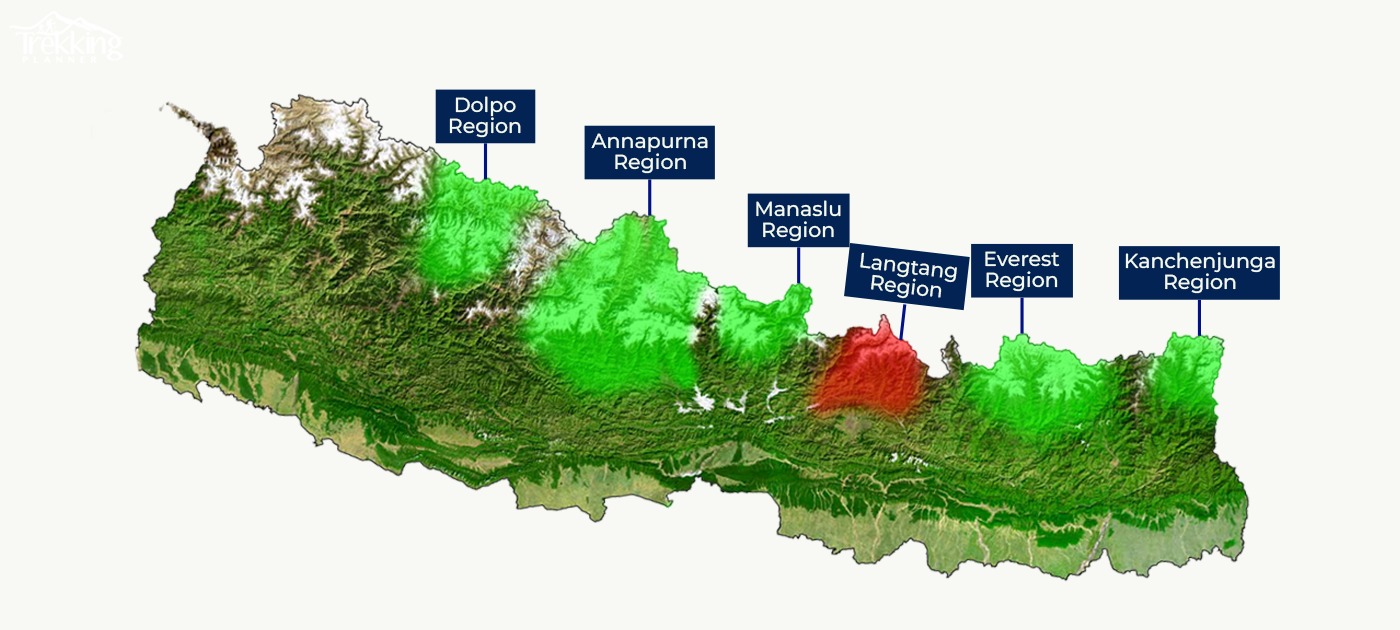
The August 26th flood caused severe damage along the Bhote Koshi corridor in Rasuwa, particularly affecting the access to the Langtang region. However, Rasuwa is only one district in the northern part of Nepal.
The Everest region (Khumbu region), the Annapurna region, Manaslu, Mustang region, Kanchenjunga and most other popular trekking regions are situated along completely different river systems or mountain ranges. These regions were not directly impacted by the Rasuwa flood and continue to welcome trekkers as usual.
In short: the Rasuwa Flash flood disaster was real and catastrophic in the impacted regions, but it does not represent the same situation across every region in Nepal.
Trekking in Nepal: Region by Region Status of Major Trekking routes
|
Trekking region |
Status |
Comments and recommendations |
|
Everest region |
Unaffected |
Normal conditions apply. |
|
Annapurna region |
Unaffected |
Normal conditions apply |
|
Manaslu region |
Trekking region unaffected, access disrupted |
The trekking region is unaffected. However, access route i.e. The Malekhu-Dhadingbesi route is affected. Alternative route: Benighat-Arughat |
|
Langtang region |
Suspended for Tourist travel |
Wait for official advisories |
|
Gosaikunda |
Suspended for Tourist travel |
Wait for official advisories |
|
Ganesh Himal & Ruby Valley |
Trekking region unaffected, access disrupted |
The trek destination remains unaffected. However, the access route via Dhunche/Syabrubesi is disrupted. Alternative approaches: via Dhadingbesi or Arughat |
|
Kanchenjunga |
Unaffected |
Normal Conditions apply |
|
Makalu |
Unaffected |
Normal Conditions apply |
|
Rolwaling |
Unaffected |
Normal Conditions apply |
|
Helambu |
Unaffected |
Normal Conditions apply |
|
Mustang |
Unaffected |
Normal Conditions apply |
|
Dhaulagiri |
Unaffected |
Normal Conditions apply |
|
Far-western trekking regions |
Unaffected |
Normal Conditions apply |
Note: This regional trekking status is as of September 6, 2026 and may change as conditions develop. Travelers should verify the latest trail, road and weather conditions before departure.
Recommended Treks for Autumn 2026
The Rasuwa Flash Flood does not mean that the entire trekking networks, routes and regions across Nepal are closed. Nepal’s major trekking routes, regions and destinations are scattered across different mountain ranges, valleys and watersheds. Therefore many major trek and tour regions remain unaffected by the floods on 26th August, 2026.
For travelers who are planning to visit Nepal during the autumn 2026 trekking season, the most appropriate alternatives are the routes that are geographically separate from the Rasuwa-Bhote Koshi corridor and whose access infrastructure remains operational.
The following treks/tours are the most prominent options to consider for Autumn 2026 trekking season:
- Everest Base Camp trek-14 days
- Everest Base Camp trek with helicopter return-11 days
- Annapurna Circuit trekking-17 days
- Annapurna Base Camp short trekking-8 days
- Upper Mustang Trekking-17 days
- Kathmandu, Pokhara and Chitwan city tour-8 days
What About Langtang Trekking after the flood?
As of 6th September 2026, All major treks in the Langtang region including Langtang Valley Trek, Gosaikunda Trek and Tamang Heritage trail have been suspended for Tourist travel until further notice. The Primary road connecting Kathmandu to Syabrubesi (The gateway to Langtang region) is extensively damaged.
The Langtang Valley trekking trail follows the Langtang Khola, a different river system from the Bhote Koshi that flooded. Current reports indicate that the upper trail toward Langtang village and Kyanjin Gompa was not directly hit by the floodwaters. However, a complete assessment of bridges, lower sections of the trail, and local infrastructure is still going on.
Syabrubesi and nearby settlements themselves have had to endure massive destruction. Many lodges, tea houses, and local services that normally support trekkers were affected. Even if trail access improves, the capacity and condition of accommodation in the gateway area may remain limited for some time.
If you have an existing booking to trek the Langtang region, what should you do?
Don’t decide everything right now.
If your trek is still several weeks away, there is no need to rush your cancellation. Road repairs and recovery are continuing, so the situation may improve by the time your dates approach. Check again with your tour operator closer to your departure date.
Confirm the actual access route.
The Primary road to Syabrubesi is still disrupted. People have looked at Dhunche as an alternative entry point to the region, but the use of this route has currently been limited to rescue and relief efforts and essential traffic only. Verify whether it is open for regular tourist vehicles before making plans.
Postponing is often better than cancelling.
If you have a flexible schedule, postponing your trek by a few weeks can be a very practical option. Conditions in the region will definitely change, and a later departure may allow normal access to resume.
If your departure is very soon, switch regions.
For trips starting within the next one to two weeks, Langtang, Gosaikunda, and other related routes in the region are not currently realistic. In these cases, switching your trek to an unaffected region such as Everest, Annapurna, Manaslu, Kanchenjunga, Dolpo and others is the more practical option.
Why is Independent Traveling risky in the current situation?
The Rasuwa floods has resulted in complexities in travel and tour arrangements due to significant damage and disruptions in various infrastructural as well as logistical aspects.Most of the regions across Nepal still remain unaffected and accessible for trekking and travelling. However, certain challenges will surely emerge for some time following the disaster.
Many roads in and around the affected regions are still in a state of recovery. Some sections have been washed away, others remain partially blocked by debris, and temporary diversions are common. Road status can change quickly after further rain or landslides. Independent travelers relying on public vehicles without guidance may face sudden delays or cancellations.
Late monsoon and early autumn season can still bring heavy rain, landslides and other calamities. In the aftermath of a major flood, slopes can remain unstable. Independent travelers may not have immediate access to current weather warnings or local hazard updates. Hence, the risk of being caught in difficult conditions increases.
Accurate, real-time information is not always easy to find online. Social media posts and older travel blogs can quickly become outdated. Official notices, local transport issues, and trail conditions are often shared first through local networks/links, trekking agencies, and people on the ground. Independent travelers can struggle to get clear, verified updates when plans need to change in a short notice.
Advantages of traveling with an experienced tour operator
- Direct access to the updates of road and trail conditions from local teams
- Opportunity to adjust itineraries, routes or timing quickly if conditions change
- Established contacts for transport, accommodation, and emergency support
- Better understanding of which areas remain disrupted and which are operating normally
- Possible to switch to an alternative region if the original plan is no longer realistic
In short, while independent travel is still possible in many parts of Nepal, the period following the Rasuwa flood requires more careful planning and flexibility than usual. Planning the trek/trip with an experienced tour operator reduces uncertainty and helps travelers respond quickly if the conditions change.
What we are telling Our Clients
In the upcoming weeks following the Rasuwa flood, we are taking a very cautious approach with all of our clients. Trekking planner Nepal’s first priority is providing the most complete and accurate information to our clients and being very responsible as well as flexible in decision making. We do not want to stay firm in terms of our original plans or itineraries.
We assess each trek and tour according to the specific region, current access, and the latest on-ground reports. Our team is continuously monitoring access routes, infrastructural reports, weather developments, and official advisories from government agencies, especially for any trek/tour packages that could be possibly influenced by the Rasuwa corridor. We rely on direct updates from our field staff and trusted local contacts rather than general online information.
If a pre-planned tour is no longer safe or practical, we can adjust the itinerary. This may mean changing the starting point, changing the access route, switching to a different region, or even postponing the trek. We will always discuss different options with our clients openly and aim to find the most suitable alternative based on their dates and preferences.
Trekking Panner Nepal’s conclusive message to our clients is simple: we are monitoring the situation closely, communicating clearly, and making decisions based on real, on-ground conditions rather than just assumptions.
How Tourism Can Support Recovery
Tourism has been a crucial pillar in Nepal’s economy, contributing approximately 6.7 to 8% of Nepal’s GDP. It also serves as the largest source of Nepal’s foreign exchange revenue. Although the Rasuwa flood caused serious damage in a particular geographical location, foreign tourists visiting Nepal and traveling to the unaffected tourist destinations and trekking regions can definitely help support the economy as a whole and the people who depend on it.
Here’s how tourism can contribute to recovery:
1. Provides income to local communities
Tourism supports local guides, porters, hotel and teahouse owners, drivers, restaurant workers, shopkeepers and many other working class people whose livelihoods depend on foreign visitors.
2. Helps local businesses recover
When tourists continue visiting destinations that are open, their spending helps hotels, restaurants, transport providers, trekking companies and other tourism businesses maintain operations and recover from losses.
3. Creates and protects employment
Tourism activity helps businesses retain employees and provides income for people and families who depend on tourism-related jobs.
4. Keeps money within local communities
Staying at locally owned accommodation, hiring local guides and porters, using local transport and purchasing local products allows more tourism revenue to circulate within affected and surrounding communities.
5. Supports the wider economy
Tourism generates demand for transportation, food, agriculture, handicrafts, accommodation and other services, creating economic activity beyond the immediate tourism sector.
6. Helps restore confidence in Nepal
Continued travel to unaffected and operational destinations definitely portrays to the world that the Rasuwa disaster was geographically limited and that many parts of Nepal continue to function normally.
7. Supports long-term recovery
Tourism cannot directly replace emergency relief or reconstruction but continued tourism activities can provide an important source of income as communities and local businesses move from immediate response toward long-term recovery.
Conclusion
The Rasuwa flash flood that occurred on 26th Aug, 2026 was a catastrophic event that caused significant loss of life, damage to infrastructure and major disruptions along the Bhote Koshi and Trishuli river corridors.The impact on local communities was also quite significant. The consequences of the flood will be felt for a long time even after the rescue and relief operations are over.
For foreign travelers, who have already booked their trip to Nepal or are planning their trip to Nepal, it is really important to understand the geography of the disaster. The impact and damage of the Rasuwa flood was concentrated in specific regions of Rasuwa, Nuwakot and surrounding areas along the Bhote Koshi and Trishuli river corridors.
Some trekking destinations, including the Langtang region, have faced serious access and infrastructure disruptions. Other major trekking regions such as Everest, Annapurna,Manaslu and others are geographically separate from the affected zones and are fully operational.
Therefore, travelers planning to visit Nepal in autumn 2026 should stay informed, check the latest official updates and remain flexible with their itineraries. Wherever the trek/travel routes are open and conditions are suitable, continuing to travel can also help support the guides, porters, accommodation providers, transportation operators and communities whose livelihoods depend on tourism.
In conclusion, Nepal is facing a difficult period of disaster recovery, but one disaster does not halt the entire country. With informed decisions and careful attention to conditions, visitors can make their plans based on clear facts & information rather than fear & assumptions while respecting the communities that are still rebuilding.
Our thoughts remain with the families of those who lost their lives and with the communities working to rebuild after this disaster.
Official Sources & Emergency Information
Official Sources:
- National Disaster Risk Reduction and Management Authority (NDRRMA)
- Nepal Police
- Department of Hydrology and Meteorology(DHM)
- Nepal Tourism Board(NTB)
- Ministry of Home Affairs(MoHA)
- Ministry of Foreign Affairs(MoFA)
- Nepal Army
- Department of Roads(DoR)
Emergency Contacts:
- Nepal Police: 100
- Traffic Police: 103
- Tourist Police: 1144 (Toll-Free)
- Tourist Police Head Office, Bhrikutimandap: +977-9851289445,+977-1-5347041