Book Now
Price from
US$1299

Ghorepani Jomsom Muktinath Trek- 14 Days

1087 reviews in TripAdvisor
238 reviews in Google
19 reviews in TrustPilot
Trip Facts
Duration
14 Days
Difficulty Level
Moderate
Maximum Altitude
3762 m
Starts
kathmandu
Ends
kathmandu
Group Size
2+
Activities
Trekking, Historical And Cultural Excursion
Season
March-June and Sept-Dec

Introduction: Ghorepani Jomsom Muktinath Trek 

Ghorepani-Jomsom-Muktinath Trail takes the trekkers right through the deepest river gorge in the world, formed by the mighty Kali Gandaki River between the famous Annapurna Massifs and the Dhaulagiri Mountain Range. Trekkers traverse along the last section of the Annapurna Circuit Trek route and through villages with diverse communities, cultures, and traditions, changing landscapes, rare wildlife, flora, and fauna, a different climate, and magnificent and glittering Himalayan ranges. Join the trekking route and experience its natural, biotic, and religious uniqueness and its richness in various aspects.

This naturally rich and diverse trail from Pokhara-Muktinath begins from the northwest of Nepal’s Tourist capital, the Lake City of Pokhara. Starting along the bank of the Modi River, the track explores the dense rhododendron forest, stone stairs, beautiful waterfalls, pristine rivers, and famous settlements such as Tikhedhunga and Ghorepani as we proceed further in the course. Witnessing one of the most surreal sunrise scenes in the famed Poonhill, the trail enters the Kali Gandaki River valley as the Kali Gandaki River accompanies us in our upstream trek along the river.

Through the settlements of Ghasa, Tukuche, Tatopani, Kagbeni, Muktinath, and others, trekkers in this trek get to the arid landscape of Jomsom and Muktinath valley and finally to the religious shrine of Muktinath, sacred for both the Buddhist and Hindu communities. Intermittently, trekkers get to experience the diversity in terms of inhabitation (such as Brahmin, Chhetri's, Thakali, Magar, and other communities), flora and fauna (including rhododendron flowers in several colors such as red, pink, white, and purple), conifers (Chestnut, Oak, Hemlock, Blue Pine, and others), Langur money, and various species of birds), landscape (from lush valleys in the lower altitude to the semi-desert terrain in and around Jomsom and Muktinath), and the panoramic view of mountain massifs including the Annapurna Range, Dhaulagiri Range, Gangapurna, Mount Nilgiri, Tukuche Peak, and Thorong Peaks, among the other mountains).

Pokhara-Ghorepani-Jomsom-Muktinath Trekking offers the trekkers extensive diversity and richness, thus scores of contrasts and myths in various dimensions. It begins with some manageable trekking sections and exposes you to moderately challenging areas during the trek, requiring the trekkers to be prepared. Explore the Kali Gandaki River Basin, the junction of the Indian and Tibetan plateaus, with its comprehensive diversity, making it an attractive trekking destination. Join us to experience the religious harmony, diversity, and enthralling landscape and scenery. On a trekking trail that reaches up to 3800m at the most, trekkers find it relatively easier to complete the trek. Join this trek as soon as possible!

Highlights of Ghorepani Jomsom Muktinath Trek

  • The trek begins with a flight towards Pokhara, which offers spectacular views of  Annapurna and Dhaulagiri.
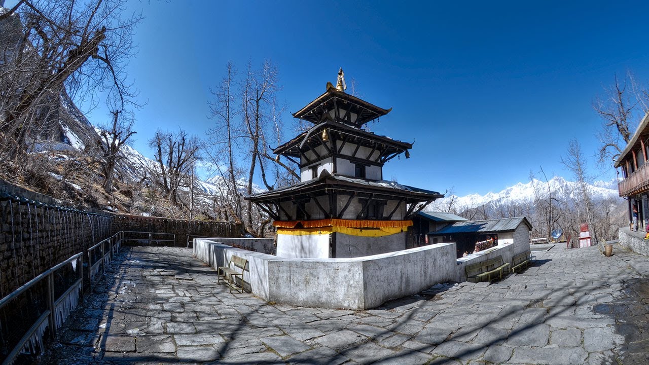
  • Muktinath Temple is a sacred site for Hindus and Buddhists at 3,710 meters.
  • Muktinath is famous for its 108 water spouts, believed to have healing powers.
  • Kagbeni Village is a charming medieval village that offers a glimpse of the traditional Mustang lifestyle.
  • Poon hill offers one of the best sunrise view in nepal of the mountains located in the Annapurna range.
  • Jomsom Bazaar is the administrative center of the Mustang region, located at an altitude of 2,700 meters.
  • Jomsom is famous for its apple orchards and is a hub for trekking and mountaineering activities.
  • The trek also offers the opportunity to relax in natural hot springs in Tatopani, a charming village at 1,200 meters.

Advantage of booking a trek with Trekking Planner Nepal

  • Private vehicles pick up and drop off passengers at all airports.
  • First-aid kit box
  • Trekking Planner’s down jackets, t-shirt, and cap—if necessary.
  • Arrangement of emergency evacuation service (you should have insurance for emergency evacuation, which will be paid for by your travel insurance company).
  • We use an oximeter to check your pulse, oxygen saturation, and heart rate, and we provide oxygen.
  • Sim cards are provided by our company for travelers, so there won’t be any networking issues.

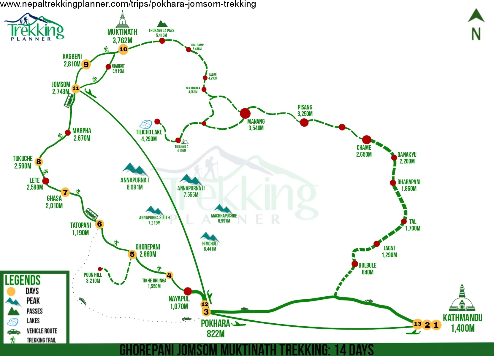
how Does the Ghorepani Jomsom Muktinath Trek Begin and End?

The Ghorepani-Jomsom-Muktinath trek is a popular trekking route in the Annapurna Region of Nepal. It typically begins in Nayapul and ends in Jomsom or Muktinath, depending on whether you're doing the entire trek or a shorter version.

We will follow this route but it can be customized as well:

  • Nayapul: The trek starts from Nayapul, which is easily accessible from Pokhara. It's a common starting point for various excursions in the Annapurna Region.
  • Tikhedhunga: After Nayapul, the trek takes you through picturesque villages and forests to reach Tikhedhunga.
  • Ghorepani: The next major destination is Ghorepani, a charming village known for its panoramic views of the surrounding mountains, including the famous Poon Hill viewpoint.
  • Tatopani: From Ghorepani, the trek descends to Tatopani, known for its natural hot springs. Tatopani is a great place to relax and rejuvenate.
  • Ghasa, Marpha, and Jomsom: The trail then passes through various villages like Ghasa and Marpha, known for their apple orchards and local culture. The trek gradually leads to Jomsom, a larger town in the region.
  • Muktinath: The trek typically ends at Muktinath Temple, a sacred pilgrimage site for Hindus and Buddhists. Muktinath is known for its temple complex and the natural elements around it.

Depending on your pace, itinerary, and acclimatization needs, the trek can be modified to a shorter or longer version. It's a diverse and rewarding trek that offers stunning mountain views, cultural experiences, and encounters with local communities.

For whom is the Ghorepani Jomsom Muktinath Trek?

Ghorepani-Jomsom-Muktinath trekking is a popular trekking route in the Annapurna Region of Nepal. It is primarily undertaken by adventure seekers, trekkers, and tourists interested in exploring the Himalayas' breathtaking landscapes, diverse culture, and natural beauty.

The trek is open to anyone who wishes to experience the majestic mountains, charming villages, and religious sites along the route. The main attractions of this trek include the beautiful rhododendron forests, stunning mountain views, the culturally rich towns of Ghorepani and Ghandruk, and the sacred temple of Muktinath, which is an important pilgrimage site for both Hindus and Buddhists.


muktinath-temple

How Hard is Trekking at Ghorepani Jomsom and Muktinath?

The Ghorepani-Jomsom-Muktinath trekking trail is a moderate trek with varying difficulty levels at different stages. The overall difficulty of the tour depends on several factors, including your fitness level, previous trekking experience, and the weather conditions during your journey. Here's a general overview of the difficulty along different sections of the trek:

  • Ghorepani to Poon Hill: The initial part of the trek from Nayapul to Ghorepani is relatively moderate. However, the early morning hike from Ghorepani to Poon Hill to witness the sunrise over the Himalayas can be challenging due to the steep ascent and the early morning cold.
  • Ghorepani to Tatopani: The trek from Ghorepani to Tatopani involves descending a considerable distance, which can be tough on the knees and muscles. The trail passes through beautiful rhododendron forests and offers stunning views.
  • Tatopani to Ghasa: This section involves walking along the Kali Gandaki River, which is relatively flat and makes for a more leisurely walk.
  • Ghasa to Marpha: The trail from Ghasa to Marpha is mostly easy, with gentle ascents and descents.
  • Marpha to Kagbeni to Jomsom: This part of the trek goes through the arid landscape of the Mustang Region. The terrain is relatively flat, which makes for comfortable walking.
  • Jomsom to Muktinath: The trail from Jomsom to Muktinath is primarily uphill, and the high altitude can make it more challenging. However, the views are stunning, and you'll pass through picturesque villages.
  • Muktinath to Jomsom (return): The return journey from Muktinath to Jomsom follows the same route, but you'll be descending, making it relatively more accessible compared to the ascent.

How to Prepare and What to Pack for the trek?

Preparing for the Poon Hill, Ghorepani, Jomsom, and Muktinath trek requires careful planning and packing of essential items to ensure a safe and enjoyable journey. Here are some tips on how to prepare and what to pack:

  • Physical Fitness: The trek involves walking for several days at varying elevations. Before the tour, exercise regularly through cardiovascular exercises, hiking, and walking to improve your stamina and endurance.
  • Obtain Permits: Before starting the trek, ensure you have obtained the necessary permits. The Annapurna Conservation Area Permit (ACAP) and TIMS (Trekkers' Information Management System) cards are required for this trek. You can obtain these permits in Kathmandu or Pokhara.

Clothing:

  • Lightweight and moisture-wicking trekking shirts and pants.
  • Warm layers are needed for cooler temperatures at higher elevations, including a down jacket or fleece jacket.
  • Windproof and waterproof jacket and pants for protection against rain and wind.
  • Thermal innerwear for colder nights.
  • A hat or cap to shield from the sun and cold.
  • Gloves and warm socks.

Footwear:

  • Sturdy and comfortable hiking boots with good ankle support.
  • A pair of lightweight trekking sandals for use around the teahouses in the evenings.

Backpack and Daypack:

  • A durable and comfortable backpack for carrying your belongings (40–50 liters of capacity is recommended).
  • A smaller daypack to carry essentials like water, snacks, a camera, and sunscreen during day hikes.

Sleeping Bag:

  • A good-quality, season-appropriate sleeping bag suitable for the trek's temperatures.

Toiletries:

  • Biodegradable soap and shampoo.
  • Toothbrush and toothpaste.
  • Hand sanitizer and wet wipes.
  • Toilet paper (available in teahouses, but it's good to carry your own).

First Aid Kit:

  • Basic first aid supplies include bandages, antiseptic ointment, pain relievers, and medication for altitude sickness.

Water and Snacks:

  • Carry a reusable water bottle and water purification tablets or a water filter to treat water from local sources.
  • Energy bars, nuts, and dried fruits make quick snacks on the trail.

Miscellaneous:

  • Sunglasses with UV protection.
  • Trekking poles for additional support during steep descents and ascents.
  • Headlamp or flashlight with extra batteries.
  • Camera and spare memory cards or batteries to capture stunning landscapes.

Personal Documents:

  • Passport and copies of necessary permits
  • Travel insurance documents.

Cash:

  • Carry enough Nepali currency (Nepalese Rupees) for the trek, as ATM facilities might be limited in the mountains.

Remember to pack light and only bring the essentials. Excess weight can make the trek more challenging. Additionally, taking a porter is advisable to help carry your luggage and consult with our trekking agencies officials to get valuable insights into the local culture and environment.

Lastly, check the weather forecast and be prepared for changing weather conditions. Layering your clothing will allow you to adjust to the temperature fluctuations during the trek.

Why Trekking Planner Nepal?

Consider choosing Trekking Planner Nepal for your trek to Muktinath, Jomsom, and Ghorepani.

  • Local Expertise: Trekking Planner Nepal is a local trekking agency based in Nepal, which means they have an in-depth understanding of the region, its culture, and the trekking routes. They will likely have experienced guides knowledgeable about the local customs and traditions and can provide valuable insights during the trek.
  • Experience and Reputation: Look for agencies with a proven track record of organizing successful treks in the region. Established trekking agencies like Trekking Planner Nepal will likely have years of experience conducting expeditions and have garnered positive reviews from previous trekkers.
  • Safety and Support: Trekking in remote mountainous regions comes with inherent risks, so it's essential to prioritize safety. Reputable agencies like Trekking Planner Nepal prioritize safety and have proper emergency protocols, including access to rescue services if needed.
  • Customized Itineraries: Trekking Planner Nepal may offer various itineraries for the Muktinath, Jomsom, and Ghorepani treks, allowing you to choose one that suits your time, fitness level, and preferences.
  • Logistics and Permits: Trekking Planner Nepal can handle the logistics, including arranging permits and paperwork required for the trek. We save you time and effort, as obtaining permits can be complex.
  • Accommodation and Meals: Trekking Planner Nepal can arrange accommodation in teahouses or lodges along the trekking route. They can also cater to dietary preferences and ensure you have access to hygienic meals during the trek.
  • Social and Environmental Responsibility: Look for Nepal Trekking Planner who supports proper waste management and respect for local communities and their culture. Responsible trekking agencies contribute positively to the local economy and environment.
  • Support Local Communities: Choosing a local trekking agency like Trekking Planner Nepal can also help support the local communities and economy by generating income and employment opportunities.

When selecting Trekking Planner Nepal, it's essential to research, read reviews from our previous trekkers, and inquire about services.

Useful Blogs

Ghorepani Jomsom Muktinath Trek- 14 Days Itinerary

Day 1

Arrival in Kathmandu 1350m/4430ft and then transfer to hotel.

Max Altitude: 1,350m (4,429ft)
Meals: welcome dinner
Accommodation: 3 star hotel

Upon arrival, you will be picked up by our office representative and transferred to the hotel. After refreshments, your tour guide will pick you up for half-day sightseeing tours to Kathmandu Durbar Square. Later this evening, we will provide you cultural welcome dinner. Stay overnight at the hotel.

Day 2

Full day in Kathmandu/trekking preparation day

Max Altitude: 1,350m (4,429ft)
Meals: breakfast
Accommodation: 3 star hotel
  • Swyambhunath Stupa
  • Patan Durbar Square 
  • Pashupatinath Temple 
  • Buddhanath stupa

Today after breakfast, you will be ready for a guided sightseeing tour to Swyambhunath stupa, known as the monkey temple, a combination between Hinduism and Buddhism, from where you can see a good view of Kathmandu valley. Drive to Patan Durbar Square (city of living arts), Pashupatinath, one of the famous Hindu temples near the holy river Bagmati and then drive to Bouddhanath stupa, one of the biggest and oldest stupas in the world. Later in the afternoon, there will be a pre-trip meeting with your trekking guide in the hotel. Our office representative will brief you regarding our trek and allow you to ask any question about an upcoming trip with a guide. And stay overnight in Kathmandu.

Day 3

Drive/Fly to Pokhara 822 m/2,697 ft, about 7hrs drive and 35 minutes in flight .

Max Altitude: 822m (2,696ft)
Meals: Breakfast
Accommodation: 3 star hotel

Today an early morning breakfast at the hotel in your hotel. Your guide will come to pick you up and transfer you to the tourist bus station for a day scenic countryside drive to the lakeside city of Pokhara. On arrival, you will move to the hotel. After refreshments, you will have half-day guided sightseeing tours to the lake, waterfall, and Cave. Stay overnight at the hotel.

Note:  You can fly to Pokhara, which takes around 35min

Day 4

Drive to Nayapul (1080m/3544ft) about 02 hrs. and trek to Tikhedhunga (1540 m/5053 ft) 3-4 hrs. walk.

Max Altitude: 1,540m (5,052ft)
Meals: Breakfast, Lunch and Dinner
Accommodation: Lodge/Guest House

Today morning, you will be picked up at the time our guide gave you the day before. You will drive on an excellent motorable road for about 45 km. The journey continues with the incredible scenery passing through several villages, Naudanda, Kanre, and Lumle, to Nayapul. On reaching Nayapul, where our adventure begins from the warm sub-tropical region, the walk follows the Modi River upstream to Birethanti & follows the east bank of Bhurungdi Khola with scenery of waterfall and high green forest. Finally reaches Tikhedhunga. Stay overnight at the tea house.

Day 5

Trek to Ghorepani 2,874m / 9,429 ft 5-6 hrs. walks.

Max Altitude: 2,874m (9,429ft)
Meals: Breakfast, Lunch and Dinner
Accommodation: Lodge/Guest House

After an early breakfast at the lodge, you will start a day trek to Ghorepani. The trail steeply ascends on the long stone steps to Ulleri village with the scenery of terrace landscape and Annapurna Himalaya range. After a few hours of the long, challenging climb with several breaks in between reaching Ulleri village, from here the path is gradual on the winding trail through the cool shade of rhododendron forest; the walk continues with a few short ups and downs to Ghorepani, from where you will able to see a nice view of Annapurna, Dhaulagiri, Tukuche and Nilgiri mountain. Stay overnight at the tea house.

Day 6

Trek to Tatopani 1190 m | 3,904 ft via Poon Hill 3,210 m/10,530 ft 6-7 hrs. walks.

Max Altitude: 1,190m (3,904ft)
Meals: Breakfast, Lunch and Dinner
Accommodation: Lodge/Guest House

Your guide will wake you up in the early morning before the sunrise hike to Poonhill about 45 minutes, and after sunrise, view from the High Mountain and the beautiful panoramic scenery of the Himalayas of the Annapurna range and Dhaulagiri range; you will go back to the hotel. This is a heart-touching place for views of the Mountain. You may have a chance to see autumn full of blooming Rhododendron flower passes en route to Poon Hill. After going back and breakfast, long downhill to Shikha, we will have lunch and continue walking down to Tatopani, crossing through the Magar villages and some other groups with different scenery and terrace field, and finally reach Tatopani. Enjoy your day in a Hot spring bath and rest. Stay overnight at the tea house lodge.

Day 7

Trek to Ghasa 2010 m/6594.485 ft 5-6 hrs. walks.

Max Altitude: 2,010m (6,594ft)
Meals: Breakfast, Lunch and Dinner
Accommodation: Lodge/Guest House

Today, after breakfast in your hotel, you will continue walking up gradually following the narrow gorge path of the high cliff, and at one tip, you have to pass through the subway carved towards the enormous rocks.  The trail goes along with the gorgeous Rukse Chhahara waterfall before reaching Ghasa. Ghasa is the first Tibetan-style beautiful rural community with lovely stone houses and acceptable narrow paths. Overnight stay at Teahouses.

Day 8

Trek to Tukuche 2595m / 8514ft 5-6 hrs. walks.

Max Altitude: 2,595m (8,513ft)
Meals: Breakfast, Lunch and Dinner
Accommodation: Lodge/Guest House

After breakfast, trek onwards to Kalopani, passing through the pine forest and the tropical scenery of the pine forest. You may have a chance to see Mt. Nilgiri, Annapurna I, and Dhaulagiri Ice-fall. After 2 hrs finally reaches Lete/Kalopani. After lunch, trek to Tukuche and overnight at the teahouse lodge with the scenery of Mt. Dhaulagiri.

Day 9

Trek to Kagbeni 2,804 m/9,199 ft 5-6 hrs. walks.

Max Altitude: 2,804m (9,199ft)
Meals: Breakfast, Lunch and Dinner
Accommodation: Lodge/Guest House

Today after breakfast in your hotel, you will continue walking up gradually, enjoying the Dhaulagiri Icefall view and Nilgiri, following upstream up to Marpha village. Marpha is a classic traditional village of Thakali from that area and garden of apples. You can visit Monastery and explore and onwards to Jomsom. From here, another two more hour’s walk brings you to Kagbeni for your overnight stay.

Day 10

Trek to Muktinath 3,762 m/12,343 ft 4-5 hrs. walks.

Max Altitude: 3,762m (12,342ft)
Meals: Breakfast, Lunch and Dinner
Accommodation: Lodge/Guest House

After a wonderful time in and around Kagbeni, after breakfast, trek onwards, further crossing the mountain desert scenery with some mountain views and reaching Muktinath. This is an essential pilgrimage for both Buddhists with a Gompa. This is an ancient and traditional village in the mountains; all houses resemble Tibetan homes and old Monasteries. Explore the area and enjoy the view. Feel different in Nepalese lifestyle and landscapes as well. Stay overnight at the tea house.

Day 11

Trek to Jomsom 2,743 m/8,999 ft via Jharkot 3519m / 11545ft 5-6 hrs. walking.

Max Altitude: 2,743m (8,999ft)
Meals: Breakfast, Lunch and Dinner
Accommodation: Lodge/Guest House

Today after breakfast in the hotel, you will re-trace down to Jomsom through several villages. On arrival, you will visit Jomsom, including the eco mountain museum. Stay overnight at the tea house.

Day 12

Fly to Pokhara.

Max Altitude: 822m (2,696ft)
Meals: Breakfast
Accommodation: 3 star hotel

Today after our last breakfast in the mountain as per our morning flight schedule, we walk up to the airport for your short but scenic flight back to the lakeside city of Pokhara, where upon arrival, you will be received by our hotel representative to help with your transfer to hotel in Pokhara. As you will have enough time today to rest and relax until noon after your lunch and short rest, you can have an optional tour sightseeing tour of the places of interest in Pokhara. The places to visit are Davies Fall, Tibetan Refugee Camp, Gupteshwor Cave, and International Mt. Museum. Stay overnight at the hotel.

Day 13

Drive back/Fly back to Kathmandu.

Max Altitude: 1,350m (4,429ft)
Meals: breakfast and farewell dinner
Accommodation: 3 star hotel

After a wonderful time in and around Pokhara, after breakfast, you will transfer to the tourist bus station for a day countryside drive back to Kathmandu. Stay overnight at the hotel.

Note:  You can fly to Pokhara, which takes 35min

Day 14

Final departure.

Meals: breakfast

Today you will transfer to the International airport for final departure.

The Ghorepani, Jomsom, and Muktinath Trek is prepared on a standard fitness basis. Some days' walks can be shorter or longer, depending on the pace. Some designated overnight stops can change. As per your physical fitness, due to available rooms and other facilities, etc.

We will follow the itinerary if it needs to be changed in case of weather, landslides, or difficulties on walks requiring more days where our leader and lead head guides decide to hold full authority for Trekking Planner Nepal.

Dates & Availability

Trip Duration
14 Days
Trip Starts & Ends Point
kathmandu / kathmandu
Plan your trek schedule
  • This trip departs every day of the year.
  • This trip is fully customizable. We can customize the trip as per your needs; please contact us.
  • This trip is available on both a fixed departure and a private group basis.
  • This trip can be booked privately if you’re traveling solo, privately, or with family.
  • Have a big group? We can help as per your needs.
  • We can help you make it fit your budget.
  • We accept instant booking and online payment.
  • If the given date is not appropriate for you, please contact us.
  • Trekking Planner also organizes various trips in small groups that can suit you.
  • We recommend you reserve a seat for yourself by booking with us right away for a wonderful experience with us.
  • Call or email now for a private trip: [email protected], mobile: +977 98510 71767 (24 hours), WhatsApp, and Viber.

Interactive Map

StartMid DaysEnd

Infographic Map

Download

Altitude Chart

Essential Information

Distance and Elevation of the Places at Ghorepani Jomsom Muktinath Trail?

Pokhara to Nayapul.

  • Distance: Pokhara and Nayapul are approximately 42–50 kilometers (26–31 miles) by road, depending on the route.
  • Altitude: Pokhara is around 827 meters (2,713 feet) above sea level. Nayapul is situated at an altitude of approximately 1,070 meters (3,510 feet) above sea level.

Nayapul to Tikhedhunga.

  • Distance: The distance from Nayapul to Tikhedhunga is approximately 10–12 kilometers (6–7.5 miles), depending on the specific path taken and the source of information.
  • Altitude: Nayapul is around 1,070 meters (3,510 feet) above sea level. Tikhedhunga is situated at an altitude of approximately 1,570 meters (5,150 feet) above sea level.

Tikhedhunga to Ghorepani.

  • Distance: The distance from Tikhedhunga to Ghorepani is approximately 8–10 kilometers (5–6.2 miles), depending on the specific route taken and the source of information.
  • Altitude: Tikhedhunga is located at an altitude of around 1,570 meters (5,150 feet) above sea level. Ghorepani is situated at an altitude of approximately 2,874 meters (9,429 feet) above sea level.

Ghorepani to Poon Hill.

  • Distance: The distance from Ghorepani to the Poon Hill viewpoint is approximately 1.5–2 kilometers (0.9–1.2 miles), depending on the starting point within Ghorepani.
  • Altitude: Ghorepani is located at an altitude of around 2,874 meters (9,429 feet) above sea level, while Poon Hill's viewpoint is at approximately 3,210 meters (10,532 feet) above sea level.

Ghorepani to Tatopani.

  • Distance: The distance from Ghorepani to Tatopani is approximately 18–20 kilometers (11.2–12.4 miles), depending on the specific route taken.
  • Altitude: Tatopani is around 1,190 meters (3,904 feet) above sea level.

Tatopani to Ghasa.

  • Distance: The distance from Tatopani to Ghasa is approximately 15–17 kilometers (9.3–10.6 miles), depending on the specific route taken and the source of information.
  • Altitude: Tatopani is situated at around 1,190 meters (3,904 feet) above sea level, while Ghasa is about 2,010 meters (6,594 feet) above sea level.

Ghasa to Tukuche.

  • Distance: The distance from Ghasa to Tukuche is approximately 7-9 kilometers (4.3–5.6 miles), depending on the specific route taken and the source of information.
  • Altitude: Ghasa is about 2,010 meters (6,594 feet) above sea level, while Tukuche is around 2,590 meters (8,497 feet) above sea level.

Tukuche to Kagbeni.

  • Distance: The distance from Tukuche to Kagbeni is approximately 12–14 kilometers (7.5–8.7 miles), depending on the specific route taken and the source of information.
  • Altitude: Tukuche is around 2,590 meters (8,497 feet) above sea level, while Kagbeni is situated at about 2,810 meters (9,219 feet) above sea level.

Kagbeni to Muktinath.

  • Distance: The distance from Kagbeni to Muktinath is approximately 8–10 kilometers (5–6.2 miles), depending on the specific route taken and the source of information.
  • Altitude: Kagbeni is about 2,810 meters (9,219 feet) above sea level, while Muktinath is around 3,710 meters (12,172 feet) above sea level.

Muktinath to Jomsom.

  • Distance: The distance from Muktinath to Jomsom is approximately 20–22 kilometers (12.4–13.7 miles), depending on the specific route taken and the source of information.
  • Altitude: Muktinath is around 3,710 meters (12,172 feet) above sea level, while Jomsom is about 2,720 meters (8,920 feet) above sea level.

What is the Local Culture and Religion around Jomsom Muktinath and Ghorepani?

During the Jomsom Muktinath and Ghorepani treks in the Annapurna Region of Nepal, you will encounter a rich and diverse local culture influenced by Hinduism and Buddhism. The area is inhabited by various ethnic groups, each with unique traditions, customs, and religious practices. Here are some critical aspects of the local culture and religion you might experience during the trek:

  • Hinduism and Buddhism: Most people in the lower elevations, such as Ghorepani and Ghandruk, follow Hinduism, while as you go higher towards Jomsom and Muktinath, you will find a strong Buddhist influence. It's not uncommon to see Hindu and Buddhist religious sites coexisting nearby.
  • Temples and Monasteries: Throughout the trek, you'll encounter numerous temples, shrines, and monasteries. Ghorepani has the famous Poon Hill viewpoint, a popular spot for sunrise views over the Himalayas, and is known for its cultural significance. Muktinath is a significant pilgrimage site for Hindus and Buddhists, with a famous temple dedicated to Lord Vishnu.
  • Festivals: If your trek coincides with local festivals, you'll have the chance to experience vibrant celebrations. Festivals like Dashain and Tihar (celebrated by Hindus) and Losar (the Tibetan New Year celebrated by Buddhists) are lively events with religious rituals, dances, and feasting.
  • Local Customs: The people in the Annapurna Region are known for their warm hospitality. You'll likely be greeted with "Namaste" (a traditional greeting) and offered tea or snacks by locals along the way. It's essential to respect local customs and show appreciation for the culture.
  • Traditional Clothing: You'll see men and women wearing traditional clothing like Daura Suruwal (a type of Nepali male dress) and Gunyu Cholo (a conventional Nepali female dress) in the lower regions. As you move into more Tibetan-influenced areas, you might encounter people wearing traditional Tibetan clothing.
  • Language: The primary language spoken in the region is Nepali, but you may also hear other regional languages like Gurung, Magar, and Thakali.
  • Traditional Cuisine: You'll taste delicious local dishes during your trek. Dal Bhat (rice with lentil soup) is a staple food; you'll find variations in different places. Thukpa (noodle soup), momo (dumplings), and Tibetan bread are popular dishes.

    Can we Get Altitude Sickness at the Highest Points of the Trek?

    Yes, altitude sickness is possible at Muktinath and Poon Hill, as both places are located at relatively high elevations in the Annapurna Region of Nepal.

  • Poon Hill: Poon Hill is a popular viewpoint located at about 3,210 meters (10,531 feet). Many trekkers visit Poon Hill early morning to witness the breathtaking sunrise over the Annapurna and Dhaulagiri Mountain ranges. While the altitude at Poon Hill is not extremely high, some people may still experience mild symptoms of altitude sickness, especially if they ascend too rapidly without proper acclimatization.
  • Muktinath: Muktinath is a significant religious site and a pilgrimage destination for Hindus and Buddhists. It is situated at approximately 3,800 meters (12,467 feet). The altitude at Muktinath is considerably higher than that at Poon Hill, and trekkers are more susceptible to altitude-related issues here, exceptionally if they have not adequately acclimatized during the trek.
  • Altitude sickness, also known as Acute Mountain Sickness (AMS), can occur when one ascends to high elevations too quickly, and the body doesn't have enough time to adjust to the decreased oxygen levels in the air. Common symptoms of AMS include headache, dizziness, nausea, loss of appetite, fatigue, and difficulty sleeping.

    Remember to stay honest with your guide and inform Trekking planner Nepal senior representatives in case of any difficulties.

    How to avoid Altitude Sickness During this trek?

    To reduce the risk of altitude sickness during the trek, it's essential to follow these guidelines:

  • Acclimatization: Take sufficient time to acclimatize at higher elevations. Spend an extra day in places like Ghorepani and Jomsom to allow your body to adapt to the altitude.
  • Hydration: Drink plenty of fluids, such as water and herbal tea, to stay hydrated at higher altitudes.
  • Gradual ascent: Avoid rapid upgrades and take a steady pace while trekking.
  • Listen to your body: Pay attention to any signs of altitude sickness and inform your guide immediately if you experience symptoms.
  • Descend if necessary: If your symptoms worsen, it's crucial to descend to a lower altitude to recover.
  • Medication: Some trekkers take preventive medicines for altitude sickness, but it's essential to consult a doctor before doing so.
  • Remember that altitude sickness can affect anyone, regardless of age or fitness level, so it's crucial to be cautious and prioritize your health during the trek. Hiring Trekking Planner Nepal for experience in altitude-related issues can also be beneficial. We can help you make informed decisions and take necessary precautions to ensure a safe and enjoyable trekking experience.

    Is Travel Insurance Required for Muktinath Jomsom or Ghorepani?

    Travel insurance is not mandatory but, we still highly recommend purchasing one before trekking to Muktinath, Jomsom, or Ghorepani. As it provides essential coverage and financial protection in case of unforeseen events or emergencies during your trekking period in Nepal.

    Here are some reasons why travel insurance is necessary for trekking in any part of Nepal:

  • Medical Emergencies: Trekking at higher altitudes has the potential risk of altitude sickness and other medical issues. Travel insurance can cover medical expenses, including evacuation by helicopter or other means if necessary.
  • Trip Cancellation or Interruption: Travel insurance can reimburse your pre-paid, non-refundable expenses in case you need to cancel or cut short your trek due to unexpected circumstances like illness, injury, or family emergencies.
  • Emergency Evacuation: In remote areas like Muktinath, Jomsom, and Ghorepani, where access to medical facilities is limited, travel insurance can cover the cost of an emergency evacuation to the nearest medical facility or back to Kathmandu, where better medical services are available.
  • Loss or Damage to Personal Belongings: Travel insurance can cover the loss, theft, or damage to your luggage, trekking equipment, and personal belongings during the trip.
  • Flight Delays or Cancellations: Weather conditions in mountainous regions can lead to flight cancellations or delays. Travel insurance can compensate you for additional expenses incurred due to such disruptions.
  • Personal Liability: In case you accidentally cause harm to someone or damage property during the trek, travel insurance may cover legal expenses and claims.
  • Before purchasing travel insurance, ensure coverage for high-altitude trekking and activities. Read the policy details carefully to understand the coverage limits, exclusions, and additional requirements for trekking in Nepal.

    Consult with Trekking Planner Nepal officials and representatives before purchasing TRAVEL INSURANCE.

  •  

Equipments

If you are preparing for a high-altitude Himalayan adventure in Nepal, there is always some confusion about what to pack. It is essential to carry the right gear and equipment for a comfortable, safe, and enjoyable experience. All trekkers should properly pack and carry all the essential items. 

However, overpacking is another common mistake that can make the journey tiring. So here is a carefully crafted packing list that includes everything you need. From general items, cloth layers, headgear, footwear, to accessories and first aid, the list consists of light and smart packing items for every challenging mountain condition.

Note: You do not need to bring all the items mentioned below to Nepal. There are several trekking shops in Kathmandu or Pokhara where you can buy or rent high-quality gear at a reasonable price. So, feel free to pack light and purchase or rent any missing items after your arrival in Nepal. Also, members from Trekking Planner Nepal Pvt. Ltd. can also guide and assist you to find the best deals in gear and equipment in Thamel, Kathmandu.

What Does the Company Provide?

  • We give you a free duffel bag (must return), buffs, trekking cap, trekking map, and t-shirt during your pre-trip meeting in Kathmandu. The duffel bag will be used to pack your trekking supplies.

  • For every two participants, we assign one porter. The porter will carry the duffel bag, which should weigh around 10 kg/22 lbs., throughout the walk.

  • We can provide a down jacket for USD 35. In case of loss or damage, you need to pay back the cost of USD 100 per item.

  • We can provide a sleeping bag for USD 35. In case of loss or damage, USD 100 per item must be paid.

  • You can safely store your extra luggage (items not required on the trek) at the hotel in Kathmandu. Our team can happily assist and help.

  • Total luggage for the Kathmandu-Lukla flight is (15 kg/33 lbs.), including duffel (10 Kg/22 lbs.) and backpack (5 kg/11 lbs.).

  • We provide a free Nepal SIM card (Ncell) to all our trekkers during the pre-trip briefing in Kathmandu. Data packages can be purchased at an additional cost.

Upper Body Layers

  • Technical fabric base layer thermals are light for warmer months, heavy for colder months
  • Technical fabric t-shirts and sleeve sweaters or high-necks
  • Fleece jacket or down jacket
  • Windproof jacket for the walk as it gets windy
  • Waterproof rain jacket
  • Sports bras (women)
Lower Body Layers

  • Thermals inner
  • Hiking pants at least 3
  • Comfortable pants for teahouses
  • Waterproof, windproof shell pants
  • Hiking shorts
  • Technical fabric/quick drying undergarments (can be washed during the trek)
  • Sleeping clothes as per the comfortability
Footwear & Accessories

  • Marino Wool or warm socks
  • Hiking socks
  • Liner socks
  • Trekking/hiking boots (waterproof recommended)
  • Crampons (for mountain passes)
  • Casual shoes or sandals that are comfortable for the time in the tea house
  • Gaiters (lightweight for rain and snow)
  • Woolen gloves for the tea house
  • Hard-shell windproof outer gloves for the walk
  • Trekking poles
Head & Sun Protection

  • Sun hat or cap (We'll provide you with a trekking cap)
  • Warm woolen hat or beanie
  • Scarf/Neck Buff (highly recommended to get saved from wind and cold)
  • Polarized sunglasses
  • Headlamp or mobile torch light for nighttime
  • Sunscreen SPF- 50+
  • Lip balm or Vaseline
  • Ointment cream
Personal & Medical Kits
  • Sunscreen SPF- 50+
  • Lip balm or Vaseline
  • Ointment cream
  • Cough Syrup and strepsils (recommended for Khumbu Cough)
  • Creams and medicines for any allergies or personal conditions
  • Small towel
  • Toilet paper, small soap, and shampoo
  • Anti-Diarrhoea, Painkillers, Blister Plasters, and Anti-Inglammatories

(Note: Our guides carry medications, oxygen cans, and first aid kits during the trip. However, personal kits and medications are recommended.)

Travel Documents

  • Passport
  • Extra copies of passport-sized photos
  • Waterproof/ziplock bags for documents and valuables
Miscellaneous

  • Reusable water bottle
  • Water bladder for daypack
  • Water purification tablets or UV purifier
  • High-protein snacks (energy bars, nuts)
  • Power bank or extra batteries
  • Universal Plug Adaptar
  • Charging Cables
  • Travel lock
  • Camera and mobile phone
  • Pillowcase (in case of allergies)
  • Sleeping clothes
  • Cards / Book
  • Thermos for hot water at night
Featured Tip
7%
Off
Price Per Person
US$1299
US$1399
  • 1 paxUS$1399
  • 2 - 6 paxUS$1299
  • 7 - 14 paxUS$1250
  • 15 - 30 paxUS$1199
Need Help? Call Us!
Dipak Lamichhane
Dipak Lamichhane
Managing Director
+977 9851071767

You May Also Like

Mountain flight over the Himalayas with Mount Everest and Kathmandu heritage sightseeing tour in Nepal
Duration: 1 Days

Mountain flight with Kathmandu Heritage Site Tour - 1 Day

KathmanduKathmandu
Per Person
US$360US$399
Trip Details
Bengal tiger roaming through the forests of Chitwan National Park
Duration: 4 Days

Chitwan National Park – 3 Nights/4 Days Package

Kathmandu/PokharaKathmandu/Pokhara
Per Person
US$240US$260
Trip Details
Jeep safari exploring the wilderness of Bardiya National Park in western Nepal
Duration: 4 Days

Bardiya National Park (3N/4D Package)

Kathmandu/PokharaKathmandu/Pokhara
Per Person
US$460US$499
Trip Details
Need Help? Call Us+977 9851071767